If you’re wondering how to get to the high path in Cinque Terre, you’re in the right spot. We were lucky enough to visit the beautiful Cinque Terre National Park during our road trip to Italy, and let me tell you, the scenery from the top of the High Path is breathtaking.
The High Mountain Path (Path 1) more or less follows the AV5T Trail from Levanto to Portovenere, although you can pick it up at various locations along the route and from the five Cinque Terre villages.
It’s perfect for hikers and nature enthusiasts, birders and those of you who want to escape the congested Blue Trail and take a walk through the pine forest. You can take it in segments or do the whole lot if you’re feeling extra committed; either way, it’s a peaceful trail not to be missed!

Uncover How To Get To The High Path In Cinque Terre And Work Out Which Sections You Want To Do With My Guide!

In this guide, I’m sharing with you all the information you’ll need on how to get to the High Path in Cinque Terre. I’ve broken it down into segments and shared our own hiking experience from Riomaggiore to Portovenere. I’ve included:
- The five segments of the High Path
- The transversal trails to reach the trail
- Hiking difficulty of each trail and tips
- The best time to go hiking in Cinque Terre.
Summary: Cinque Terre High Path Hiking Trails
- 1/a. Portovenere – Pass of Telegrafo
- 1/b. Pass of Telegrafo – Cigoletta
- 1/c. Cigoletta – Termine
- 1/d. Termine – S. Antonio Mesco/Cape of Mesco
- 1/e. S. Antonio Mesco/Cape of Mesco – Levanto
High Path Cinque Terre Map
Other useful maps of Cinque Terre:
How To Get To The High Path In Cinque Terre: AV5T/Path 1

Length: 40 km
Journey time: 12 hours
Segments: 5 (with multiple transversal paths)
Before I crack on with the breakdown of each segment, I’ve written a more in-depth description of our hike for you. Hopefully, after you’ve read it, you’ll be extra excited about hiking along the High Path in Cinque Terre!
The majority of the route is through the pine forest, although the best parts, 1/a and 1/e, are the sections not to be missed, as you’ll get the best views along the coastline!
I recommend breaking the journey up over two/three days and combining sections of the High Path and the Blue Trail (more on this below).
In fact, I recommend spending three days in Cinque Terre and only visiting if you’re a keen hiker. Otherwise, you might be in for a shock! Read our article on whether Cinque Terre is worth visiting or not here.
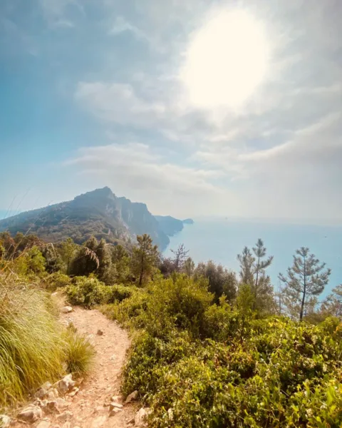
Let me just say the 1/a. Portovenere to Pass of Telegrafo section was one of the best hikes we did in Italy. If you’re keen to know more, I’ve written more about our experience at the bottom of this article.
However, let’s get started on how to get to the High Path in Cinque Terre with a breakdown of each segment so you can easily work out which route you want to take.
Let’s go.
1/a. Portovenere – Pass of Telegrafo

Highest Point:1864 ft / 568 m.
Length: 8.5 km / 5.5 miles.
Journey time: 3 to 4 hours.
This is the section of the High Path we did in Cinque Terre and is probably the most popular section. It starts in Portovenere at the main square, although we did it in reverse, instead starting near Riomaggiore before reaching Telegrafo (Google Maps).
From Telegrafo to Portovenere, the hike is much easier, with less of an incline and better views, which is why most hikers choose to start at this end rather than in Portovenere.
Either way, it is a stunning hike with a mixture of scenery: vineyards, pine forests, villages and many viewpoints. The rugged trail passes through the small village of Campligia Tramonti (Google Maps), which is a good place to rest and grab a bite.

There are trails from Campligia Tramonti leading down to the shore, where a number of beaches are located. Spiaggia del Nacchè, Monesteroli Beach and Spiaggia del Persico, to name a few.
⭐ Pro tip >> Section 1/a will end at the Pass of Telegrafo. From here, you can catch a bus to Riomaggire or hike down. We hiked down, or up, I should say.
HOW TO GET TO CINQUE TERRE HIGH PATH FROM PORTOVENERE
The trailhead starts at Piazza Giacomo Bastreri (Google Maps). This will take you along a staircase behind the old town to Castle Doria. From Castle Doria, follow the trail ascending into the treeline; you’ll be able to see the Gulf of La Spezia behind you.
The views are much better coming in the opposite direction as you’ll be walking towards the Gulf of La Spezia rather than away from it!
Alternatively, there is a side trail leading to Muzzerone Fortress and passing the landmark Faro Storico (Google Maps). It can be quite challenging to reach, and the trail is steep with a lot of loose rock, however, the view is said to be amazing.


HOW TO GET TO CINQUE TERRE HIGH PATH FROM RIOMAGGIORE
The 501/Path 01 is the direct trail and takes about an hour and a half.
However, there is a nice path which passes the Santuario di Nostra Signora di Montenero (Google Maps). From Riomaggiore, pick up the 593V trail, which will lead you to the church. From there, join trail SVA/ Path 3 until it diverges at AV5T/Path 1.
If you’re coming from Telegrafo, you can do this in reverse.
1/b. Pass of Telegrafo – Cigoletta

Highest Point: 2461 ft / 750 m.
Length: 6 km / 3.7 miles.
Journey time: 2 to 3 hours.
From Telegrafo, the next segment is a 6 km hike to Cigoletta.
Along the hike, you’ll pass Bramapane Hill, where Forte Bramapane (Google Maps) is located. It’s one of the only landmarks along this segment of the High Path in Cinque Terre, and although overgrown, the ruined building deserves a quick stop.
The path traverses the hill’s summit, popping in and out of the pine forest and providing extensive vistas of the coastline.
Section 1/b will end at Cigoletta.

HOW TO GET TO CINQUE TERRE HIGH PATH FROM MANAROLA
There are numerous routes from Manarola to the High Path; however, the most direct is Trail 506/Path 6, which passes through Volastra. It’s about 4 km, and you’ll join the AV5T/Path 1. This is best if you’re heading westbound along the trail.
If you don’t fancy walking, there is a bus from Manarola to Volastra.
Alternatively, if you’re heading southbound, you have a few more choices. Trail 502/Path 02 is the most direct route, and you can detour through Groppo if you fancy passing another village which also features the Agricultural Cooperative Society 5 Terre winery (Google Maps).
1/c. Cigoletta – Termine

Highest Point: 2665 ft / 812 m.
Length: 8.5 km / 5.3 miles.
Journey time: 3 to 3.5 hours.
From Cigoletta, the next segment is an 8.5 km hike to Termine.
This trail is completely through the forest, with few chances of seeing the shoreline. For this reason, it’s one of the least favoured segments of the AV5T. That said, it’s great for peaceful hiking through woodland with plenty of opportunity to spot birds, mushrooms and other wildlife.
There are no landmarks on this trail, and section 1/c will end at the Termine bus stop interjunction.
HOW TO GET TO CINQUE TERRE HIGH PATH FROM CORNIGLIA
One of the most straightforward trails to reach the high mountain path from any of the five Cinque Terre villages, you’ll need to pick up Trail 587/Path 7a, which starts on the outskirts of Corniglia behind Chiesa Di San Pietro.
The route diverts off the main trail and goes behind Case Pianca (Google Maps) to join the SP51 for a short walk before twisting back off into the trees, eventually leading to AV5T/Path 1 and joining at Cigoletta.


HOW TO GET TO CINQUE TERRE HIGH PATH FROM VERNAZZA
From Vernazza, there are two options. If you plan to head southbound along the High Path, you’ll want to pick up Trail 507/Path 7. It will lead you through two villages: San Berardino and Fornacchi. There’s a viewpoint at the Church of Madonna di San Bernardino (Google Maps), which delivers breathtaking views over Vernazza.
For those of you heading north, you’ll be looking for Trail 508/Path 8. It passes Santuario di Nostra Signora di Reggio (Google Maps) before joining the AV5T/Path 1; there’s also Cafè Bistrot PZ (Google Maps), an espresso bar. It’s worth a stop for refreshments and features fantastic views.
1/d. Termine – S. Antonio Mesco

Highest Point: 1527 ft / 465 m.
Length: 7 km / 4.3 miles.
Journey time: 3 to 3.5 hours.
This segment of the trail starts at the Termine bus stop interjunction and continues into the hills before u-turning back towards the coast; it’s a 7 km hike to S. Antonio Mesco/ Punto Mesco.
Access to the trail is down the road (SP51) on the opposite side, ascending rocky steps to the right. It’s well signposted. The hike begins through the pine forest and weaves its way around to the Mesco Cape, a stupendous scenic point.
Along the way, there’s the popular Santuario Nostra Signora di Soviore (Google Maps), a hotel and a popular scenic point with a restaurant overlooking the hills.
Once you turn south towards the cape, the forest begins to clear, and you’ll get beautiful views of the shoreline as you meander along the edge of the mountain.
The AV5T trail ends at Hotel il Colle. From there, you’ll pick up the 591 and follow it to Punto Mesco.

HOW TO GET TO CINQUE TERRE HIGH PATH FROM MONTEROSSO AL MARE
From Monterosso al Mare, you can pick up trail 509/Path 9, which will take you directly to Santuario Nostra Signora di Soviore. From there, walk along SP38 eastbound, and you’ll come across a narrow road on the left. On this road, there’s a small passage through the trees which connects to AV5T/Path 1.
Use the above route if you’re heading southbound along the High Path in Cinque Terre.
Alternatively, you can walk along road SP38 to Hotel il Colle (Google Maps) and pick up the 591 trail/Path 1 (1/d.) to Punto Mesco.
If you don’t fancy walking, there is a bus from Monterosso al Mare to Santuario Nostra Signora di Soviore.
1/e. S. Antonio Mesco – Levanto

Highest Point: 1070 ft / 326 m.
Length: 4.5 km / 2.8 miles.
Journey time: 2 to 2.5 hours.
From Cape of Mesco, it’s a 4.5 km hike to Levanto along Trail SL/Path 1 (1/e.).
This segment of the Cinque Terre High Path is also very popular since the views along the coast are unbelievable. Again, it’s best to do this hike in reverse, from Levanto to Punto Mssco, so you’re walking towards the five villages.

At the scenic point, you’ll witness the best view of Cinque Terre National Park.
Much like the first part of this route, the SL trail will lead you along a rugged, rocky path built into the rock face and hugging the shoreline.
⭐ Pro tip >> The main attraction along this segment is the Podere Case Lovara (Google Maps), which is an ancient farm renovated by the FAI with a recovery program based on sustainability. You can visit the farm.
Alternative Cinque Terre Paths
The Blue Trail
Most people who visit Cinque Terre stick to the Blue Trail. The Sentiero Azzurro hugs the coastline from Monterosso al Mare to Riomaggiore and provides panoramic views. It’s a well-trodden route and one of the best ways to explore Cinque Terre.
It’s around 11 km/6.9 miles point to point, reaching 1,719 ft/524 meters and can be completed in about 5 hours.
For more info, these guys have written a fantastic guide! The Blue Trail Cinque Terre Hike.
Our Experience: Riomaggiore To Portovenere On The 1/a.

We started just outside Riomaggiore since we were travelling in our campervan and needed somewhere to park. We found a good spot on SP37, pretty much opposite the Uwabiocinqueterre Vineyard (Google Maps).
The hardest part about the High Path is getting to it; since it’s at the top of the ridge, the climb can be quite intense! However, we were already halfway there as the SP37 runs above the villages across Cinque Terre National Park.
The first stop was Santuario di Nostra Signora di Montenero (Google Maps), which we reached after climbing carved steps through the vineyard – a nice warm-up. The church was closed when we arrived; however, the views over the Italian Riviera were spectacular.

We could see Riomaggiore and Manarola along the coastline in the distance, both villages glistening in the morning sun.
From Santuario di Nostra Signora di Montenero, we picked up the SVA trail heading south (or east, however, you want to refer to it) towards Portovenere. This weaves through the vineyards along a rocky, dusty path (we were there in late September) until it joins the AV5T trail at Telegrafo.
From here, we were on the High Mountian Path.


Pass of Telegrafo To Portovenere
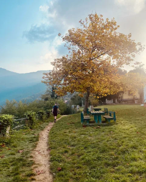
At Telegrafo, the scenery changed, and we began hiking through the woods rather than the landscaped vineyards. It was a nice change, although the views were restricted. Nevertheless, we enjoyed hiking through the leaves, spotting mushrooms, and, in a number of places, there was a light mist shrouding the trees.
The forest path led us to the village of Campiglia Tramonti (Google Maps); it’s cute, with good views of the sea and the small church of Chiesa Cattolica Parrocchiale di Santa Caterina V.M. We stopped for lunch here at Erbo Gianco (Google Maps) and had a delicious, warm vegetable tart.


From Campiglia we continued onto Portovenere. This part of the trail was my favourite. There’s an initial road walk after leaving the village, but then it turns off onto a dirt path which clutches the mountain. Embedded into the cliffs, the trail winds around the coast with stunning scenery.
The hike was a little more challenging as there were boulders to climb over and steep edges to watch out for, but overall, it was the best part. FYI, this section of the trail in Cinque Terre is also known as Promontorio Peppe Carrubba.
At the end of Promontorio Peppe Carrubba, you’ll find a viewpoint with some benches and a small coffee stall, which is actually a retro van selling snacks – Gitana on the road. From there, we took a short hike through the trees before joining the road again.
This small road continues to a small parking area – Parcheggio Muzzerone (Google Maps) – before heading into the woods again and straight onto Portovenere.
Fort Muzzerone Or Portovenere
At Parcheggio Muzzerone, it’s possible to diverge off the AV5T and head to Fort Muzzerone. There is a trail from the fort that reconnects to the AV5T, which also passes Faro Storico. landmark/cave (Google Maps).
We continued along the main trail. Eventually, the path begins to descend. This part of the hike can be tricky for those of you with bad knees, as it’s rather rocky and steep in some areas.
However, the reward is dazzling views over the peninsula and with Castello Doria (Google Maps) standing proud on the promontory, we were happy to have chosen this route. We walked along the towering walls of Castle Doria before working our way down a set of giant stone steps until we reached the main square, Piazza Giacomo Bastreri (Google Maps), gladly finishing our hike with some sweet treats!
The High Path Cinque Terre: Difficulty Level
Overall, the high path in Cinque Terre isn’t too challenging. The hardest part is getting to the top of the ridge, but once you’ve reached it, the gradient is manageable. In fact, the hike is mostly considered a MODERATE difficulty.
Here are the Cinque Terre hikes broken down into their difficulty level:
- 1/a. Portovenere – Pass of Telegrafo: Moderately Strenuous
- 1/b. Pass of Telegrafo – Cigoletta: Moderate
- 1/c. Cigoletta – Termine: Moderate
- 1/d. Termine – S. Antonio Mesco: Easy
- 1/e. S. Antonio Mesco: – Levanto: Easy
When Is The Best Time To Hike Cinque Terre?
The Cinque Terre National Park is a highly sought-after tourist destination that remains open throughout the year, regardless of the season. However, keep in mind that trail closures caused by landslides can occur at any time, although these are more frequent during winter.
Winter is not an ideal time to hike in the High Mountains since the weather is usually drab and wet, making it difficult and muddy to hike.
The peak tourism season in Cinque Terre is July and August, and the paths can get congested, although the High Path is generally much less busy than other routes, such as the Blue Trail.
Additionally, during this time, it’s going to be really hot weather although the trees offer much protection, there are exposed sections of this hike, especially the first and final segments.
If you plan to visit during the summer, I recommend setting off early in the morning to enjoy the best trail conditions and increase your chances of wildlife spotting.
⭐ Pro tip >> For a better hiking experience, it’s best to plan your visit during the shoulder months on either side of the peak season. In this case, it’s April or May and September or October. During this time, the weather is more comfortable, and the skies are typically clear.
Cinque Terre High Path Hiking Tips / Equipment
It’s really important to take plenty of water and snacks with you. Along the High Path, there are not many places to refuel once you’re on it, especially along the middle sections of the trail.
It’s worth remembering that sections 1/b and 1/c are almost completely through the woods, and the views aren’t that great. I recommend breaking up the route and combining sections of both the High Path and the Blue Trail for the best Cinque Terre hiking experience.
I also suggest breaking this journey into two or three days, so you have ample time to explore the villages. If you need to, consider using the train between the villages; at 5 euros, a single journey is affordable. It’s a quick and efficient way to move between the villages if you’re short on time or tired.
Sun protection is also important if you’re hiking sections 1/a, 1/d, 1/e and the Blue Trail as they are exposed. Wear sunscreen, dress in breathable layers and have a good hat and sunglasses.
If you want the best experience, I recommend starting early in the morning. It will be the calmest time, with the least number of people; you’ll also have the best weather and optimal photo lighting. If you’re spotting wildlife, they are most active during the early hours, too.
⭐ Pro tip >> Finally, remember all the Cinque Terre hikes can be done in either direction. 1/a. Portovenere to Pass of Telegrafo and 1/e. S. Antonio Mesco/Cape of Mesco to Levanto: I actually suggest doing it in reverse for better views and easier hiking!
What To Pack?
- Sunscreen | Make sure you protect your skin.
- Sun Hat / Cap & Sunglasses | Protect your head and eyes from the sun.
- Water Bottle | We always leave the hotel with our water bottle; it is our favourite.
- Hiking Boots | These are the most comfy hiking boots for all-day walking.
- Trekking Poles | Great for protecting your knees and back and provisioning balance.
- Rain Jacket | If you’re visiting during winter, pack a lightweight waterproof jacket.
Resources For Italy
Is it your first time visiting Italy? We’ve written lots of useful posts to help you plan your trip. You can check them all out on our Italy Page here, but below are some of our most popular articles:
- Read this article if you want to discover the most charming towns on the Italian Riviera; it includes the five Cinque Terre villages and a load more!
- Are you heading to Piedmont? We’ve written a 7-day road trip itinerary for you.
- Discover why we loved Lake Maggiore and the reasons to visit.
- Finally, you’ll love the Borromean Islands if you enjoy Cinque Terre!
⭐ Pro tip >> If you’re going to be using your phone, don’t forget about overseas data roaming. You’ll get charged for using your data. Try Airalo’s eSIMs and download a digital data pack. It’s quick and easy; great if you’re in a hurry.


In Summary: How To Get To The High Path, Cinque Terre
As always, I want to finish with a few final thoughts about hiking the High Path in Cinque Terre. If you’ve read this whole guide, you’ll know that there are sections of the High Path that aren’t great for coastal views as it goes through the forest; however, for birders, these are the best parts of the route.
It’s likely you’ll need to break the High Path hike into sections as, overall, it takes about twelve hours to complete. For the best experience, consider splitting the trail over two or three days and combining it with sections of the Blue Trail. This will allow you time to visit the villages, enjoy the trail and have additional downtime during your visit.
We hope you have found this hiking guide to the Cinque Terre High Path useful and that it’s helped you plan your trip. Happy hiking!

Explore & Discover More
Come and join our socials and keep up to date with the latest adventures. Find the latest travel photos and blog updates, ask questions and get travel inspiration.
✔️ FIND ON INSTAGRAM
✔️ JOIN US ON FACEBOOK